Ever since I bought my first bike in March, my addiction to cycling has been growing each day. Cycling combines transportation, exercise, sightseeing, data collection and analyze together, which makes is super fun for me. My favorite thing to do after a bike ride is to check out data collected by the Garmin bike computer, and sync it with different tools like MyWindSock, Wandrer.earth, and of course, Strava.
Boston is a small city, and it is super easy to get around with a bike. However, it can be intimidating to ride with motor vehicle traffic. Good news is, there’re plenty of nice dedicated cycling trails in and out of the city. Here’re some of my favorite cycling trails around Boston.
(These are just individual, separated trails, not necessarily cycling routes. There’ll be another post about cycling routes, where I combine road cycling with these cycling trails)
Minuteman
Length: 10 miles
Easiness: 2/5 (5 being the hardest)
Pavement: Paved
Minuteman bike trail is probably the most famous and popular bike trail in Boston area. It starts at the Alewife T station in Cambridge, going through Arlington, Lexington and ends at Bedford depot with a beautiful display of an old train. Bikes are allowed on the T at most of time (except rush hours) and most of stations (except Park St & Downtown Crossing). Minuteman trail is mostly well shaded with trees along the route, making it a comfortable and nice ride even with hot summer weather.
Since it goes through Arlington and Lexington town centers, you can get some good food and drinks along the way. Avenue Deli in Lexington has great sandwiches. Lexington visitor center is right next to the bike trail, which has a bathroom inside.
It is a dedicated trail for bikes and pedestrians. If you’re anxious or not comfortable riding with a lot of vehicle traffic, Minuteman is great for you. So it could be crowded during weekends, which can significantly slow down your speed. You should also have a bell to give pedestrians an early warning when approaching.
Reformatory Branch Trail
Length: 4 miles
Easiness: 1/5
Pavement: Gravel
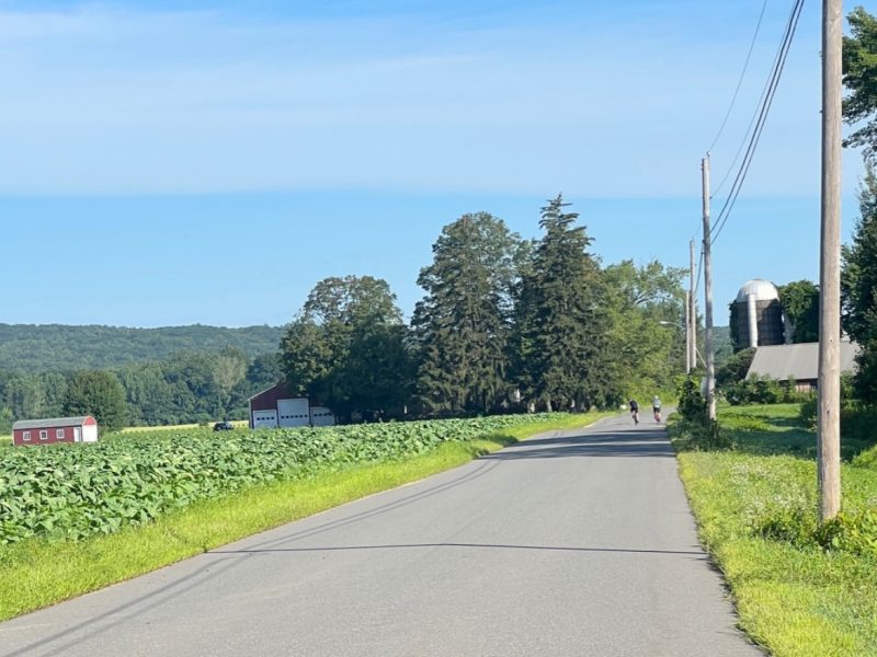
Ride for a few mins along Railroad Ave from the end of Minuteman Trail, you’ll see a trail head with a gravel parking lot. That’s Reformatory Branch trail, which is not paved. It ends in Concord. The trail end is not very far from Concord center.
It’s not easy to find gravel trails around the city. But Reformatory is a nice surprise when I went on a ride. Some places the trail is really narrow, which is super fun. There’re constant topology change, small uphill / downhill, and sometimes you need to cycle around a huge tree in the middle of the trail.
Southwest Corridor to Arboretum
Length: 3.7 miles
Easiness: 4/5
Southwest Corridor is a lovely park that runs from South End all the way to the Arboretum. However, it is cut off from Mass Ave T station to Ruggles T station. So this section only covers from Ruggles T to the arboretum. And it’s also the most bike friendly section.
Some parts of the corridor has separated pedestrians / cycling lanes. It runs through Jamaica Plain neighborhood, which is also super cute. The pavement though isn’t very nice, especially after the recent fix where they tried to make it better by covering the tree veins but they actually made it worse. The patches on the trail are higher than the original pavement.
I make the trail run all the way into the arboretum and to the top of Bussey Hill. It is super fun to ride to the top of the hill, but it can be hard (thus the 4 easiness). But it’s totally worth the effort when you’re going downhill. You can reach almost 30mph if the trail is clear.
On your way back, you should stop by Third Cliff Bakery in JP (Jamaica Plain). They have great coffees and delicious pastries. What could be better than a sip of coffee and some tasty baked goods after a bike ride?!
Dr Paul Dudley White Bike Path – Charles River Greenway
Length: ~12 miles
Easiness: 2/5
This is easily the most beautiful bike path in Boston. Starting from Charles Esplanade, the view shifts from vibrant city life to quiet suburban and forest environment. Most of the trail is well covered, but some areas are exposed to the sun. So bring enough water!
The section from Longfellow Bridge to Mass Ave Bridge is very crowded on a good weather day, so be prepared to slow down for pedestrians. Passing Mass Ave Bridge it gets quieter and it’s easier to pick up some speed.
At Watertown / Newton, you’ll have to cross the river on the cute Charles River Greenway Bridge. The trail is complicated at some places, so you should have navigation either on your phone or your bike computer if you’re not familiar with the bike path.
Keep riding down the street at the end of the trail to find some nice restaurants in Waltham. My goto one is INDULGENZA DESSERTS & PASTRIES. Simple, fast and relaxing.
Since the bike path is running along the river, there’s not much ascending / descending. It’s very flat. And it starts right in the heart of the city, so it’s very easy to get to.